Accurate flood risk surveys for planning applications
Posted 10 Dec 2025
Why flood risk matters in planning
The UK has a significant shortage of new homes and land search is a constant challenge. This makes understanding the flood risk potential of an area of land fundamental to the planning process, influencing where and how construction can safely take place. It’s no surprise with climate change increasing the frequency and intensity of rainfall that planning authorities want to see a clear demonstration of flood risk for planning and any mitigating actions.
It’s not just a planning ‘nice to have’ either – the regulatory National Planning Policy Framework (NPPF) and local climate resilience goals also demand robust flood risk surveys to evidence that new developments will remain safe for their lifetime with no negative impact on the surrounding area. Without a comprehensive flood risk assessment, planning applications may be refused, meaning expensive redesigns, missed timescales and potentially higher insurance premiums. Proving that your construction project aligns with planning and flood risk policies is now more important than ever.
What is a flood risk survey?
A flood risk survey is a technical investigation that evaluates all potential sources of flooding affecting a site. The findings of this investigation inform a formal Flood Risk Assessment (FRA) or flood risk assessment report, a must have by planning authorities for developments in higher-risk areas.
There are several similar terms used in the context of flood risk assessments for planning so here’s some simple definitions to highlight the differences:
- Flood Risk Assessment (FRA): This is a comprehensive document that analyses flood hazards, mitigation measures, and compliance with policy. Other terms that also relate to this process are flood risk assessment for planning, national flood risk assessment, engaging a flood risk assessor or flood risk consultant.
- Flood Risk Survey: This happens on-site and is all the data that can be collected from topographical, hydrological and drainage information, to inform the FRA. Surveys often incorporate applications of topographical survey data, historical flood records, hydrological modelling, and Environment Agency datasets, such as the Environment Agency flood map for planning.
- Drainage Strategy: This is a plan that demonstrates how foul water and surface water will be managed and may include sustainable drainage systems (SuDS), drainage field design, and whether a combined drainage system or separate systems for foul water drainage and rainwater drainage are most suited.
Do I need a flood risk survey?
Good question! The answer is probably yes if:
- The site lies within Flood Zone 2 or 3, as defined by government mapping
- The development is larger than 1 hectare, even in lower-risk areas
- There is known susceptibility to flooding from groundwater or surface water
- Local authorities or drainage boards request further evidence
To give yourself the best chance of planning success it worth remembering that planning officers and the Environment Agency expect clear justification showing the need for a flood risk assessment and how your proposed development complies with drainage and flood policy. It may also be necessary to discharge planning conditions relating to drainage or mitigation.
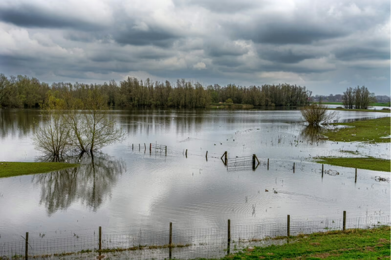
Types of flood risks considered
Flood risk professionals will quantify each type of flood risk using hydrological modelling, site surveys, and the Environment Agency flood map for planning. A quality flood risk survey will look at several causes of flooding:
- Fluvial flooding: Flooding from watercourses or rivers, including where flood defences may fail or overtop.
- Surface water flooding: This is the natural flow of water over the ground and could include drainage systems failing to cope with the volume of rain. SuDS and strategic layout design are good solutions for reducing this risk.
- Groundwater flooding: If the water table rises above the ground surface, then this will cause groundwater flooding. To understand the risk of this you’ll need data on soil permeability, geology and groundwater levels.
- Sewer and infrastructure-related flooding: Blockages or surcharges in foul or combined drainage systems. To assess the risk of this, assessors must understand what is foul water drainage, how sewer systems interact and the role of drainage boards in managing local catchments.
- Coastal flooding: If yours is a shoreline development the tides, storm surges and erosion in the area will need to be factored in.
How flood risk surveys support planning applications
Get an accurate flood risk survey to improve the outcomes of your application:
- Demonstrating policy compliance: Gathering robust evidence shows that your proposal meets national and local flood risk and planning requirements.
- Informing site layout and design: With your survey in hand, you’ll know the best place to position your building and access points, which also indicates the best spots for SuDS features or drainage infrastructure.
- Identifying mitigation measures: Understanding your flood risk survey means you can add further detail to your applications to cover off finished floor levels, flood resilience measures, compensatory storage or landscape modifications.
- Supporting Sustainable Drainage Systems (SuDS): A flood risk survey often feeds directly into the site’s drainage strategy, addressing rainwater drainage, foul water drainage, drainage field design, and where necessary, engagement with the Lead Local Flood Authority or Drainage Boards.
- Reducing objections and planning delays: Knowing that you have instructed and presented a clear, properly prepared flood risk assessment report reduces the chance of repeated requests for clarification or further modelling.
Benefits of early engagement with flood risk specialists
It’s always best to gather as much information at the start of a project so appointing experienced flood risk assessment consultants early on provides several advantages:
- Avoid costly redesigns because of emerging flood hazards or drainage issues that emerge further down the line.
- Improve project viability because you’ll know about any building constraints and opportunities upfront.
- Streamline communication with planning bodies, the Environment Agency, Lead Local Flood Authorities and other drainage authorities.
- Complete required documents so that your flood risk consultant has the FRA, drainage strategy or mitigation plans ready before submission deadlines.
DSA’s experience in flood risk assessments and planning
Building in the proximity of a river always makes for a desirable location, but potentially higher flood risk. Here at DSA, we’ve helped to obtain planning permission for many developments in Flood Zone 2 & 3, with several examples near to the River Nene, River Great Ouse and River Cherwell:
- Large and small housing developments near to rivers in Stony Stratford, Northampton, and north of Banbury.
- A new access road to industrial premises next to the River Nene near Northampton, which crosses the floodplain.
- An historic mill house on the River Nene situated entirely in Flood Zone 3 where the property owner wished to completely re-level terraces to external areas.
Our starting point is to complete site surveys, desktop assessments and engage with the Environment Agency. From here we propose the levels for the new buildings, roads and other operational areas so that they are safely raised above the modelled floodplain. Available landscaped areas around the site are then designed to be lowered, extended and re-engineered to provide safe floodplain compensation, often providing significant benefit to the wider community by allowing greater volumes of flood water to be stored on the development site than before. Digital ground models of the existing and proposed site layouts are prepared, to give an accurate picture of the improvements that can be presented to the Environment Agency and other local authorities.
Most of our projects require a drainage strategy to be developed. Rainfall and run-off from the existing site are assessed and quantified. New drainage systems are then designed incorporating Sustainable Drainage Systems (SuDS) to manage any increase in post-development flow rates and volumes. The storage structures and flow controls we design are practical, work well for the development site and providing flood risk benefits to downstream areas off-site.
At a new development site of 100 houses at Fenny Compton, DSA ensured the new drainage systems, storage basin and flow controls were adopted by Severn Trent Water. Our assessments and designs were used to satisfy the local planning authority and Network Rail that runoff from the development was well managed, meeting local and national policy requirements, and offering an improvement to the existing situation in relation to surface water drainage and flooding.
Comprehensive flood risk assessment, better planning outcomes
An accurate, well-executed flood risk survey is essential in modern development. It underpins the flood risk assessment process, guides sustainable design, satisfies planning policy compliance and reduces delays. Only when you understand, and address, all potential sources of flooding, whether it be from surface water, rivers, groundwater, sewers and more, can you develop safe, resilient and sustainable construction.
Get DSA involved early and we’ll help you prepare robust planning applications that include strong evidence to support your application.


